About Kone
Kone is a caldera(s) rising to 1,380 meters (4,528 feet) in Ethiopia's Eastern Africa Volcanic Regions. Its last known eruption was in 1820 CE. The volcano has produced 1 recorded eruption, with a maximum Volcanic Explosivity Index (VEI) of 1.
Geography & Climate
Kone is located in Ethiopia, within the Main Ethiopian Rift Volcanic Province of the broader Eastern Africa Volcanic Regions. Situated at 8.81° N, 39.69° E in the Northern Hemisphere, the volcano lies within a tropical climate zone. With a summit elevation of 1,380 meters above sea level, Kone is a moderately sized peak that remains accessible to hikers and researchers for much of the year. The volcanic landform is characterized as a caldera, which describes the physical shape and structure of the volcanic edifice as observed from the surface.
Geological Context
Kone is situated along a rift zone, where tectonic plates are pulling apart. As the crust thins and fractures, magma rises to fill the gap, creating volcanic activity. Rift volcanism typically produces more fluid lava flows rather than explosive blasts, which means communities near Kone in Ethiopia generally face slower-moving hazards like lava flows and ground fissures rather than sudden pyroclastic events. However, rift volcanoes can still generate significant ash emissions and gas releases that affect local air quality. The dominant rock type is rhyolite, a silica-rich volcanic rock associated with highly viscous magma. Rhyolitic eruptions can be extremely explosive and are responsible for some of the largest volcanic events in Earth's history, including supervolcanic caldera-forming eruptions. The high silica content traps dissolved gases, building enormous pressure that can lead to catastrophic explosive releases.
Eruption History Summary
Kone has 1 recorded eruption in the geological database, spanning from 1820 CE to 1820 CE. The most powerful recorded event was a gentle, effusive event in 1820 CE, reaching VEI 1 on the Volcanic Explosivity Index.
GVP Reference Summary
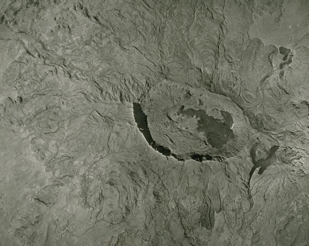
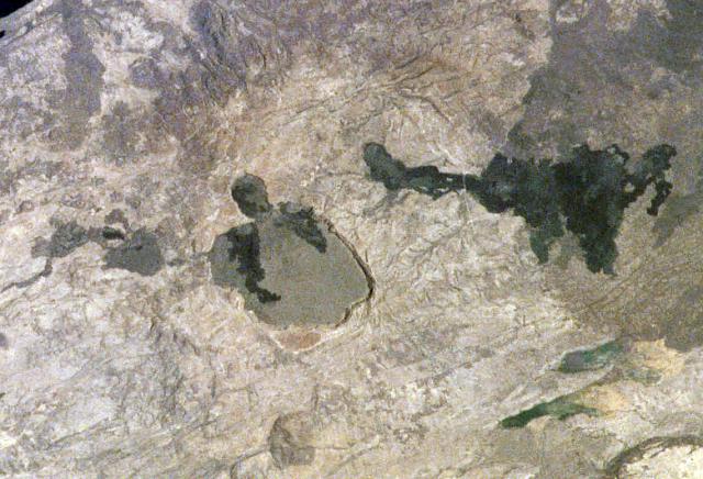
The Kone volcanic complex (also known as Gariboldi) is composed of a series of silicic calderas and young basaltic cinder cones and lava flows about 30 km SW of Fentale volcano in the Main Ethiopian Rift. As many as eight silicic calderas are accompanied by ignimbrite outflow sheets. Kone, the youngest caldera, is an elliptical 5 x 7.5 km structure trending E-W and oriented perpendicular to the rift. The rim rises about 100 m above the caldera floor; the eastern rim overlaps with a smaller elliptical caldera. Regional fissures trending roughly N-S cut across the caldera and its flanks. The youngest basalts were erupted during the first half of the 19th century from vents along a hinge line between the smaller eastern caldera (Korke) and the larger western one. A dark lava flow from a cone near the center of the southern caldera (Birenti), extended 12 km SW, where the caldera rim had been eroded, and surrounded older cones.
— Smithsonian Institution, Global Volcanism Program
1 Recorded Eruption
| Year | VEI | Type | Area |
|---|---|---|---|
| 1820 | 1 | Confirmed Eruption | East margin of Gariboldi caldera |
Real-Time Data
Frequently Asked Questions About Kone
Is Kone an active volcano?+
Kone is classified as active based on credible evidence of past eruptions. Although its last known eruption was in 1820 CE, volcanologists consider it capable of erupting again.
When did Kone last erupt?+
The most recent recorded eruption of Kone occurred in 1820 CE with a Volcanic Explosivity Index (VEI) of 1. The eruption was classified as a "Confirmed Eruption." Kone has 1 recorded eruption in total.
How high is Kone?+
Kone has a summit elevation of 1,380 meters (4,528 feet) above sea level. At 1,380 meters, it is a moderately sized volcanic peak, roughly comparable to Mount Vesuvius (1,281m).
What type of volcano is Kone?+
Kone is classified as a Caldera(s). Caldera(s) volcanoes have distinct geological characteristics that set them apart from other volcanic types.
Where is Kone located?+
Kone is located in Ethiopia, in the Eastern Africa Volcanic Regions. More specifically, it lies within the Main Ethiopian Rift Volcanic Province. Its exact coordinates are 8.810° latitude, 39.695° longitude.
Is it safe to visit Kone?+
Kone can generally be visited, but as with any volcano, visitors should check local conditions and any advisory notices before traveling. Ethiopia may have specific regulations for accessing volcanic areas. Guided tours are often the safest and most informative way to experience a volcano.