About Kiska
Kiska is a stratovolcano rising to 1,220 meters (4,003 feet) in United States's North America Volcanic Regions. It last erupted in 1990 CE, and volcanologists consider it an active volcanic system. The volcano has produced 7 recorded eruptions, with a maximum Volcanic Explosivity Index (VEI) of 3.
Geography & Climate
Kiska is located in United States, within the Aleutian Ridge Volcanic Arc of the broader North America Volcanic Regions. Situated at 52.10° N, 177.60° E in the Northern Hemisphere, the volcano lies within a temperate climate zone. With a summit elevation of 1,220 meters above sea level, Kiska is a moderately sized peak that remains accessible to hikers and researchers for much of the year. The volcanic landform is characterized as a composite, which describes the physical shape and structure of the volcanic edifice as observed from the surface.
Geological Context
Kiska sits in a subduction zone, where one tectonic plate dives beneath another, creating intense heat and pressure that generates magma. Subduction zones are responsible for many of the world's most explosive volcanoes and deadliest eruptions. For communities in United States near Kiska, this tectonic setting means the volcano is capable of producing powerful explosive eruptions, pyroclastic flows, and lahars that can threaten populated areas within tens of kilometers of the summit. The dominant rock type is andesite / basaltic andesite, a dark, fine-grained volcanic rock that forms from rapidly cooling, low-viscosity lava. Basaltic eruptions tend to be less explosive and produce fluid lava flows that can travel long distances. While less immediately dangerous than explosive eruptions, basaltic lava flows can destroy structures and infrastructure in their path, and volcanic gases released during these eruptions can affect air quality over a wide area.
Eruption History Summary
Kiska has 7 recorded eruptions in the geological database, spanning from 1907 CE to 1990 CE. The most powerful recorded event was a severe eruption capable of regional ash fall and pyroclastic flows in 1962 CE, reaching VEI 3 on the Volcanic Explosivity Index. This eruption frequency indicates a moderately active volcanic system with periodic reawakenings. The most recent eruption in 1990 CE places this volcano within the modern era of volcanological observation.
Significance
With a maximum recorded VEI of 3, Kiska has produced eruptions capable of generating pyroclastic flows and significant ash fall in the surrounding area. While not among the largest eruptions globally, VEI 3 events pose serious hazards to local populations and can disrupt regional air travel. With 7 recorded eruptions on file, Kiska has enough documented activity to help scientists identify patterns in its eruptive behavior. Given its recent activity, Kiska is closely monitored by geological survey organizations to provide early warning of future unrest.
GVP Reference Summary
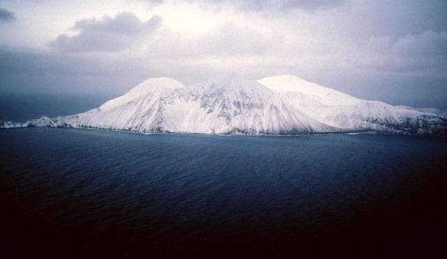
Conical Kiska volcano is the westernmost historically active volcano of the 2500-km-long Aleutian arc. The volcano lies at the northern tip of the elongated Kiska Island, across a low isthmus containing East Kiska and West Kiska lakes. A 400-m-wide elliptical crater, breached to the north, caps the 1220-m-high stratovolcano. The volcano is surrounded on three sides by sea cliffs up to 450 m high and overlies an older volcanic center exposed to the south. A massive submarine debris-avalanche deposit extends 40 km to the NNW. The southern part of the NE-SW-trending island, the westernmost of the Rat Island group, has been glaciated, but all lava flows post-date the last major glaciation. Young, steep-sided blocky lava flows, primarily on the N and SW flanks, have originated from vents at locations ranging from the summit to near sea level. A flank cinder cone and associated lava flows were erupted in 1962 at Sirius Point on the northern coast. The island contains one of the best harbors in the Aleutian Islands, but is uninhabited.
— Smithsonian Institution, Global Volcanism Program
7 Recorded Eruptions
| Year | VEI | Type | Area |
|---|---|---|---|
| 1990 | 2 | Confirmed Eruption | Upper NW? flank |
| 1987 | — | Uncertain Eruption | — |
| 1969 | 2 | Confirmed Eruption | — |
| 1964 | 0 | Confirmed Eruption | — |
| 1962 | 3 | Confirmed Eruption | North flank (Sirius Point) |
| 1927 | 2 | Uncertain Eruption | — |
| 1907 | 2 | Uncertain Eruption | — |
Real-Time Data
Frequently Asked Questions About Kiska
Is Kiska an active volcano?+
Yes, Kiska is considered an active volcano. Its most recent eruption was in 1990 CE. The volcano is monitored by geological agencies, and its activity status is based on observed eruptions within recorded history.
When did Kiska last erupt?+
The most recent recorded eruption of Kiska occurred in 1990 CE with a Volcanic Explosivity Index (VEI) of 2. The eruption was classified as a "Confirmed Eruption." Kiska has 7 recorded eruptions in total.
How high is Kiska?+
Kiska has a summit elevation of 1,220 meters (4,003 feet) above sea level. At 1,220 meters, it is a moderately sized volcanic peak, roughly comparable to Mount Vesuvius (1,281m).
What type of volcano is Kiska?+
Kiska is classified as a Stratovolcano. Stratovolcanoes (also called composite volcanoes) are steep, conical volcanoes built up by many layers of hardened lava, tephra, and volcanic ash. They are among the most common and dangerous types, known for explosive eruptions.
Where is Kiska located?+
Kiska is located in United States, in the North America Volcanic Regions. More specifically, it lies within the Aleutian Ridge Volcanic Arc. Its exact coordinates are 52.103° latitude, 177.602° longitude.
Is it safe to visit Kiska?+
Visiting Kiska requires checking current volcanic activity and alert levels. As an active volcano with eruptions as recent as 1990 CE, conditions can change rapidly. Always consult local geological authorities and follow official warnings before visiting. Many active volcanoes have designated safe viewing areas and guided tour options.