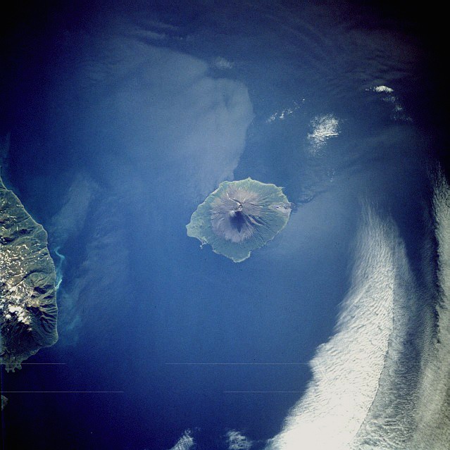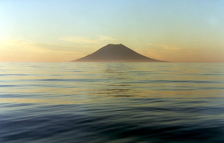
About Alaid
Alaid is a stratovolcano rising to 2,285 meters (7,497 feet) in Russia's Northwestern Pacific Volcanic Regions. The volcano is currently active, with its most recent eruption in 2022 CE. The volcano has produced 17 recorded eruptions, with a maximum Volcanic Explosivity Index (VEI) of 4.
Geography & Climate
Alaid is located in Russia, within the Kuril Volcanic Arc of the broader Northwestern Pacific Volcanic Regions. Situated at 50.86° N, 155.56° E in the Northern Hemisphere, the volcano lies within a temperate climate zone. At 2,285 meters above sea level, Alaid rises above the surrounding terrain into montane or subalpine conditions. The elevation creates distinct ecological zones along its flanks, from forested lower slopes to exposed rocky terrain near the summit. The volcanic landform is characterized as a composite, which describes the physical shape and structure of the volcanic edifice as observed from the surface.
Geological Context
Alaid sits in a subduction zone, where one tectonic plate dives beneath another, creating intense heat and pressure that generates magma. Subduction zones are responsible for many of the world's most explosive volcanoes and deadliest eruptions. For communities in Russia near Alaid, this tectonic setting means the volcano is capable of producing powerful explosive eruptions, pyroclastic flows, and lahars that can threaten populated areas within tens of kilometers of the summit. The dominant rock type is basalt / picro-basalt, a dark, fine-grained volcanic rock that forms from rapidly cooling, low-viscosity lava. Basaltic eruptions tend to be less explosive and produce fluid lava flows that can travel long distances. While less immediately dangerous than explosive eruptions, basaltic lava flows can destroy structures and infrastructure in their path, and volcanic gases released during these eruptions can affect air quality over a wide area.
Eruption History Summary
Alaid has 17 recorded eruptions in the geological database, spanning from 1790 CE to 2022 CE. The most powerful recorded event was a cataclysmic eruption with ash columns reaching the stratosphere in 1981 CE, reaching VEI 4 on the Volcanic Explosivity Index. Notable eruptions include 1981 CE (VEI 4), 1972 CE (VEI 3), 1860 CE (VEI 3). This level of eruptive frequency indicates a persistently active volcanic system that warrants ongoing monitoring. With eruptive activity as recently as 2022 CE, Alaid remains an actively monitored volcano.
Significance
With a maximum recorded VEI of 4, Alaid has demonstrated the capacity for significant explosive eruptions that can impact regional aviation, agriculture, and communities tens of kilometers from the summit. VEI 4 eruptions produce ash columns reaching 15-25 kilometers into the atmosphere. With 17 recorded eruptions, Alaid has a substantial eruptive history that provides valuable data for understanding volcanic behavior and assessing future hazards in the Northwestern Pacific Volcanic Regions region. Given its recent activity, Alaid is closely monitored by geological survey organizations to provide early warning of future unrest.
GVP Reference Summary
The highest and northernmost volcano of the Kuril Islands, Alaid is a symmetrical stratovolcano when viewed from the north, but has a 1.5-km-wide summit crater that is breached open to the south. This basaltic to basaltic andesite volcano is the northernmost of a chain constructed west of the main Kuril archipelago. Numerous pyroclastic cones are present the lower flanks, particularly on the NW and SE sides, including an offshore cone formed during the 1933-34 eruption. Strong explosive eruptions have occurred from the summit crater beginning in the 18th century. Reports of eruptions in 1770, 1789, 1821, 1829, 1843, 1848, and 1858 were considered incorrect by Gorshkov (1970). Explosive eruptions in 1790 and 1981 were among the largest reported in the Kuril Islands.
— Smithsonian Institution, Global Volcanism Program
17 Recorded Eruptions
| Year | VEI | Type | Area |
|---|---|---|---|
| 2022 | 2 | Confirmed Eruption | — |
| 2018 | 1 | Confirmed Eruption | Summit crater |
| 2015 | 1 | Confirmed Eruption | Summit crater |
| 2012 | 2 | Confirmed Eruption | Summit crater |
| 1997 | — | Uncertain Eruption | — |
| 1996 | 2 | Confirmed Eruption | — |
| 1986 | 2 | Confirmed Eruption | — |
| 1982 | 2 | Confirmed Eruption | — |
| 1981 | 4 | Confirmed Eruption | — |
| 1981 | 2 | Confirmed Eruption | — |
| 1973 | — | Uncertain Eruption | — |
| 1972 | 3 | Confirmed Eruption | NW foot |
| 1933 | 2 | Confirmed Eruption | East submarine flank (Taketomi) |
| 1894 | 2 | Confirmed Eruption | — |
| 1860 | 3 | Confirmed Eruption | — |
| 1854 | 3 | Confirmed Eruption | — |
| 1790 | 4 | Confirmed Eruption | — |
Real-Time Data
Frequently Asked Questions About Alaid
Is Alaid an active volcano?+
Yes, Alaid is considered an active volcano. Its most recent eruption was in 2022 CE. The volcano is monitored by geological agencies, and its activity status is based on observed eruptions within recorded history.
When did Alaid last erupt?+
The most recent recorded eruption of Alaid occurred in 2022 CE with a Volcanic Explosivity Index (VEI) of 2. The eruption was classified as a "Confirmed Eruption." Alaid has 17 recorded eruptions in total.
How high is Alaid?+
Alaid has a summit elevation of 2,285 meters (7,497 feet) above sea level. At 2,285 meters, it is comparable in height to many significant mountain peaks and stands well above the tree line.
What type of volcano is Alaid?+
Alaid is classified as a Stratovolcano. Stratovolcanoes (also called composite volcanoes) are steep, conical volcanoes built up by many layers of hardened lava, tephra, and volcanic ash. They are among the most common and dangerous types, known for explosive eruptions.
Where is Alaid located?+
Alaid is located in Russia, in the Northwestern Pacific Volcanic Regions. More specifically, it lies within the Kuril Volcanic Arc. Its exact coordinates are 50.861° latitude, 155.565° longitude.
Is it safe to visit Alaid?+
Visiting Alaid requires checking current volcanic activity and alert levels. As an active volcano with eruptions as recent as 2022 CE, conditions can change rapidly. Always consult local geological authorities and follow official warnings before visiting. Many active volcanoes have designated safe viewing areas and guided tour options.