About Fuss Peak
Fuss Peak is a stratovolcano rising to 1,742 meters (5,716 feet) in Russia's Northwestern Pacific Volcanic Regions. Its last known eruption was in 1854 CE. The volcano has produced 11 recorded eruptions, with a maximum Volcanic Explosivity Index (VEI) of 3.
Geography & Climate
Fuss Peak is located in Russia, within the Kuril Volcanic Arc of the broader Northwestern Pacific Volcanic Regions. Situated at 50.27° N, 155.25° E in the Northern Hemisphere, the volcano lies within a temperate climate zone. With a summit elevation of 1,742 meters above sea level, Fuss Peak is a moderately sized peak that remains accessible to hikers and researchers for much of the year. The volcanic landform is characterized as a composite, which describes the physical shape and structure of the volcanic edifice as observed from the surface.
Geological Context
Fuss Peak sits in a subduction zone, where one tectonic plate dives beneath another, creating intense heat and pressure that generates magma. Subduction zones are responsible for many of the world's most explosive volcanoes and deadliest eruptions. For communities in Russia near Fuss Peak, this tectonic setting means the volcano is capable of producing powerful explosive eruptions, pyroclastic flows, and lahars that can threaten populated areas within tens of kilometers of the summit. The dominant rock type is andesite / basaltic andesite, a dark, fine-grained volcanic rock that forms from rapidly cooling, low-viscosity lava. Basaltic eruptions tend to be less explosive and produce fluid lava flows that can travel long distances. While less immediately dangerous than explosive eruptions, basaltic lava flows can destroy structures and infrastructure in their path, and volcanic gases released during these eruptions can affect air quality over a wide area.
Eruption History Summary
Fuss Peak has 11 recorded eruptions in the geological database, spanning from 5340 BCE to 1933 CE. The most powerful recorded event was a severe eruption capable of regional ash fall and pyroclastic flows in 1854 CE, reaching VEI 3 on the Volcanic Explosivity Index. Notable eruptions include 1854 CE (VEI 3), 1250 CE (VEI 3), 1590 BCE (VEI 3). This level of eruptive frequency indicates a persistently active volcanic system that warrants ongoing monitoring. The most recent eruption in 1933 CE places this volcano within the modern era of volcanological observation.
Significance
With a maximum recorded VEI of 3, Fuss Peak has produced eruptions capable of generating pyroclastic flows and significant ash fall in the surrounding area. While not among the largest eruptions globally, VEI 3 events pose serious hazards to local populations and can disrupt regional air travel. With 11 recorded eruptions, Fuss Peak has a substantial eruptive history that provides valuable data for understanding volcanic behavior and assessing future hazards in the Northwestern Pacific Volcanic Regions region.
GVP Reference Summary
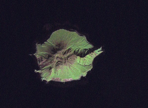
Fuss Peak forms a peninsula that lies across a low isthmus on the SW coast of Paramushir Island in the northern Kuriles. This isolated symmetrical andesitic stratovolcano has a 700-m-wide, steep-walled crater that is 300 m deep. A deep notch cuts the NW rim of the crater to the level of the crater floor, at the head of a canyon that reaches the coast. Well-preserved lava flows occupy the middle and lower flanks, particularly on the E and SE sides. Only one unambiguous recorded eruption, in 1854 CE, is known; reports of eruptions in 1737, 1793, 1857, and 1859 are false (Gorshkov, 1970). Murayama (1987) also listed an eruption in 1742 (only earthquakes and a tsunami are cited by Sapper, 1917) and "smoke" emission in 1933.
— Smithsonian Institution, Global Volcanism Program
11 Recorded Eruptions
| Year | VEI | Type | Area |
|---|---|---|---|
| 1933 | — | Uncertain Eruption | — |
| 1854 | 3 | Confirmed Eruption | — |
| 1742 | — | Uncertain Eruption | — |
| 1250 | 3 | Confirmed Eruption | — |
| 1590 BCE | 3 | Confirmed Eruption | — |
| 1850 BCE | 1 | Confirmed Eruption | — |
| 3150 BCE | 3 | Confirmed Eruption | — |
| 3850 BCE | 2 | Confirmed Eruption | — |
| 4850 BCE | 1 | Confirmed Eruption | — |
| 5250 BCE | 2 | Confirmed Eruption | — |
| 5340 BCE | 3 | Confirmed Eruption | — |
Real-Time Data
Frequently Asked Questions About Fuss Peak
Is Fuss Peak an active volcano?+
Fuss Peak is classified as active based on credible evidence of past eruptions. Although its last known eruption was in 1854 CE, volcanologists consider it capable of erupting again.
When did Fuss Peak last erupt?+
The most recent recorded eruption of Fuss Peak occurred in 1933 CE. The eruption was classified as a "Uncertain Eruption." Fuss Peak has 11 recorded eruptions in total.
How high is Fuss Peak?+
Fuss Peak has a summit elevation of 1,742 meters (5,716 feet) above sea level. At 1,742 meters, it is a moderately sized volcanic peak, roughly comparable to Mount Vesuvius (1,281m).
What type of volcano is Fuss Peak?+
Fuss Peak is classified as a Stratovolcano. Stratovolcanoes (also called composite volcanoes) are steep, conical volcanoes built up by many layers of hardened lava, tephra, and volcanic ash. They are among the most common and dangerous types, known for explosive eruptions.
Where is Fuss Peak located?+
Fuss Peak is located in Russia, in the Northwestern Pacific Volcanic Regions. More specifically, it lies within the Kuril Volcanic Arc. Its exact coordinates are 50.267° latitude, 155.246° longitude.
Is it safe to visit Fuss Peak?+
Fuss Peak can generally be visited, but as with any volcano, visitors should check local conditions and any advisory notices before traveling. Russia may have specific regulations for accessing volcanic areas. Guided tours are often the safest and most informative way to experience a volcano.