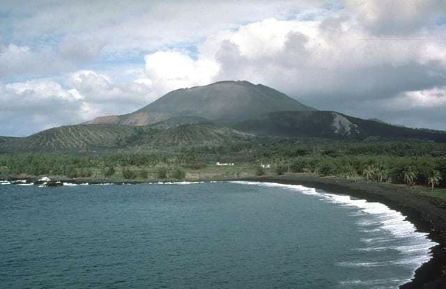
About Agrigan
Agrigan is a stratovolcano rising to 965 meters (3,166 feet) in United States's Northwestern Pacific Volcanic Regions. It last erupted in 1917 CE, and volcanologists consider it an active volcanic system. The volcano has produced 1 recorded eruption, with a maximum Volcanic Explosivity Index (VEI) of 4.
Geography & Climate
Agrigan is located in United States, within the Mariana Volcanic Arc of the broader Northwestern Pacific Volcanic Regions. Situated at 18.77° N, 145.67° E in the Northern Hemisphere, the volcano lies within a tropical climate zone. With a summit elevation of 965 meters above sea level, Agrigan is a moderately sized peak that remains accessible to hikers and researchers for much of the year. The volcanic landform is characterized as a composite, which describes the physical shape and structure of the volcanic edifice as observed from the surface.
Geological Context
Agrigan sits in a subduction zone, where one tectonic plate dives beneath another, creating intense heat and pressure that generates magma. Subduction zones are responsible for many of the world's most explosive volcanoes and deadliest eruptions. For communities in United States near Agrigan, this tectonic setting means the volcano is capable of producing powerful explosive eruptions, pyroclastic flows, and lahars that can threaten populated areas within tens of kilometers of the summit. The dominant rock type is basalt / picro-basalt, a dark, fine-grained volcanic rock that forms from rapidly cooling, low-viscosity lava. Basaltic eruptions tend to be less explosive and produce fluid lava flows that can travel long distances. While less immediately dangerous than explosive eruptions, basaltic lava flows can destroy structures and infrastructure in their path, and volcanic gases released during these eruptions can affect air quality over a wide area.
Eruption History Summary
Agrigan has 1 recorded eruption in the geological database, spanning from 1917 CE to 1917 CE. The most powerful recorded event was a cataclysmic eruption with ash columns reaching the stratosphere in 1917 CE, reaching VEI 4 on the Volcanic Explosivity Index. The most recent eruption in 1917 CE places this volcano within the modern era of volcanological observation.
Significance
With a maximum recorded VEI of 4, Agrigan has demonstrated the capacity for significant explosive eruptions that can impact regional aviation, agriculture, and communities tens of kilometers from the summit. VEI 4 eruptions produce ash columns reaching 15-25 kilometers into the atmosphere.
GVP Reference Summary
The highest of the Marianas arc volcanoes, Agrigan contains a 500-m-deep, flat-floored caldera. The elliptical island is 8 km long; its summit is the top of a massive 4000-m-high submarine volcano. Deep radial valleys dissect the flanks of the thickly vegetated stratovolcano. The elongated caldera is 1 x 2 km wide and is breached to the NW, from where a prominent lava flow extends to the coast and forms a lava delta. The caldera floor is surfaced by fresh-looking lava flows and also contains two cones that may have formed during the only historical eruption in 1917. This eruption deposited large blocks and 3 m of ash and lapilli on a village on the SE coast, prompting its evacuation.
— Smithsonian Institution, Global Volcanism Program
1 Recorded Eruption
| Year | VEI | Type | Area |
|---|---|---|---|
| 1917 | 4 | Confirmed Eruption | — |
Real-Time Data
Frequently Asked Questions About Agrigan
Is Agrigan an active volcano?+
Yes, Agrigan is considered an active volcano. Its most recent eruption was in 1917 CE. The volcano is monitored by geological agencies, and its activity status is based on observed eruptions within recorded history.
When did Agrigan last erupt?+
The most recent recorded eruption of Agrigan occurred in 1917 CE with a Volcanic Explosivity Index (VEI) of 4. The eruption was classified as a "Confirmed Eruption." Agrigan has 1 recorded eruption in total.
How high is Agrigan?+
Agrigan has a summit elevation of 965 meters (3,166 feet) above sea level. At 965 meters, it is a relatively low-elevation volcano.
What type of volcano is Agrigan?+
Agrigan is classified as a Stratovolcano. Stratovolcanoes (also called composite volcanoes) are steep, conical volcanoes built up by many layers of hardened lava, tephra, and volcanic ash. They are among the most common and dangerous types, known for explosive eruptions.
Where is Agrigan located?+
Agrigan is located in United States, in the Northwestern Pacific Volcanic Regions. More specifically, it lies within the Mariana Volcanic Arc. Its exact coordinates are 18.770° latitude, 145.670° longitude.
Is it safe to visit Agrigan?+
Visiting Agrigan requires checking current volcanic activity and alert levels. As an active volcano with eruptions as recent as 1917 CE, conditions can change rapidly. Always consult local geological authorities and follow official warnings before visiting. Many active volcanoes have designated safe viewing areas and guided tour options.