About Izu-Tobu
Izu-Tobu is a pyroclastic cone(s) rising to 1,406 meters (4,613 feet) in Japan's Northwestern Pacific Volcanic Regions. It last erupted in 1989 CE, and volcanologists consider it an active volcanic system. The volcano has produced 7 recorded eruptions, with a maximum Volcanic Explosivity Index (VEI) of 4.
Geography & Climate
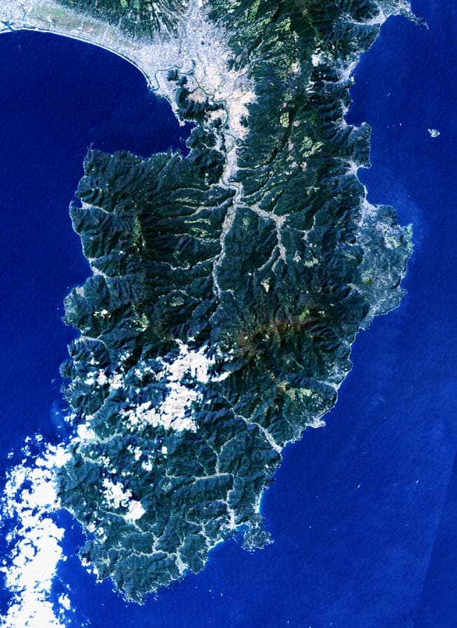
Izu-Tobu is located in Japan, within the Izu Volcanic Arc of the broader Northwestern Pacific Volcanic Regions. Situated at 34.90° N, 139.10° E in the Northern Hemisphere, the volcano lies within a subtropical climate zone. With a summit elevation of 1,406 meters above sea level, Izu-Tobu is a moderately sized peak that remains accessible to hikers and researchers for much of the year. The volcanic landform is characterized as a cluster, which describes the physical shape and structure of the volcanic edifice as observed from the surface.
Geological Context
Izu-Tobu sits in a subduction zone, where one tectonic plate dives beneath another, creating intense heat and pressure that generates magma. Subduction zones are responsible for many of the world's most explosive volcanoes and deadliest eruptions. For communities in Japan near Izu-Tobu, this tectonic setting means the volcano is capable of producing powerful explosive eruptions, pyroclastic flows, and lahars that can threaten populated areas within tens of kilometers of the summit. The dominant rock type is basalt / picro-basalt, a dark, fine-grained volcanic rock that forms from rapidly cooling, low-viscosity lava. Basaltic eruptions tend to be less explosive and produce fluid lava flows that can travel long distances. While less immediately dangerous than explosive eruptions, basaltic lava flows can destroy structures and infrastructure in their path, and volcanic gases released during these eruptions can affect air quality over a wide area.
Eruption History Summary
Izu-Tobu has 7 recorded eruptions in the geological database, spanning from 8050 BCE to 1989 CE. The most powerful recorded event was a cataclysmic eruption with ash columns reaching the stratosphere in 1150 BCE, reaching VEI 4 on the Volcanic Explosivity Index. Notable eruptions include 750 BCE (VEI 3), 1150 BCE (VEI 4), 2100 BCE (VEI 4). This eruption frequency indicates a moderately active volcanic system with periodic reawakenings. The most recent eruption in 1989 CE places this volcano within the modern era of volcanological observation.
Significance
With a maximum recorded VEI of 4, Izu-Tobu has demonstrated the capacity for significant explosive eruptions that can impact regional aviation, agriculture, and communities tens of kilometers from the summit. VEI 4 eruptions produce ash columns reaching 15-25 kilometers into the atmosphere. With 7 recorded eruptions on file, Izu-Tobu has enough documented activity to help scientists identify patterns in its eruptive behavior. Given its recent activity, Izu-Tobu is closely monitored by geological survey organizations to provide early warning of future unrest.
GVP Reference Summary
The Izu-Tobu volcano group (Higashi-Izu volcano group) is scattered over a broad, plateau-like area of more than 400 km2 on the E side of the Izu Peninsula. Construction of several stratovolcanoes continued throughout much of the Pleistocene and overlapped with growth of smaller monogenetic volcanoes beginning about 300,000 years ago. About 70 subaerial monogenetic volcanoes formed during the last 140,000 years, and chemically similar submarine cones are located offshore. These volcanoes are located on a basement of late-Tertiary volcanic rocks and related sediments and on the flanks of three Quaternary stratovolcanoes: Amagi, Tenshi, and Usami. Some eruptive vents are controlled by fissure systems trending NW-SE or NE-SW. Thirteen eruptive episodes have been documented during the past 32,000 years. Kawagodaira maar produced pyroclastic flows during the largest Holocene eruption about 3,000 years ago. The latest eruption occurred in 1989, when a small submarine crater was formed NE of Ito City.
— Smithsonian Institution, Global Volcanism Program
7 Recorded Eruptions
| Year | VEI | Type | Area |
|---|---|---|---|
| 1989 | 1 | Confirmed Eruption | Teishi-kaikyu (4 km NE of Ito City) |
| 1930 | — | Uncertain Eruption | 3.6 km NE of Teishi-jima |
| 750 BCE | 3 | Confirmed Eruption | Iwano-yama, Iyuzan, and other vents |
| 1150 BCE | 4 | Confirmed Eruption | Kawagodaira |
| 2050 BCE | — | Confirmed Eruption | Yoichizaka |
| 2100 BCE | 4 | Confirmed Eruption | Omuro-yama |
| 8050 BCE | 3 | Confirmed Eruption | Akakubo |
Real-Time Data
Frequently Asked Questions About Izu-Tobu
Is Izu-Tobu an active volcano?+
Yes, Izu-Tobu is considered an active volcano. Its most recent eruption was in 1989 CE. The volcano is monitored by geological agencies, and its activity status is based on observed eruptions within recorded history.
When did Izu-Tobu last erupt?+
The most recent recorded eruption of Izu-Tobu occurred in 1989 CE with a Volcanic Explosivity Index (VEI) of 1. The eruption was classified as a "Confirmed Eruption." Izu-Tobu has 7 recorded eruptions in total.
How high is Izu-Tobu?+
Izu-Tobu has a summit elevation of 1,406 meters (4,613 feet) above sea level. At 1,406 meters, it is a moderately sized volcanic peak, roughly comparable to Mount Vesuvius (1,281m).
What type of volcano is Izu-Tobu?+
Izu-Tobu is classified as a Pyroclastic cone(s). Pyroclastic cones (or cinder cones) are small, steep-sided volcanic cones built from fragments of lava blasted into the air. They are the simplest type of volcano and often form in groups.
Where is Izu-Tobu located?+
Izu-Tobu is located in Japan, in the Northwestern Pacific Volcanic Regions. More specifically, it lies within the Izu Volcanic Arc. Its exact coordinates are 34.900° latitude, 139.098° longitude.
Is it safe to visit Izu-Tobu?+
Visiting Izu-Tobu requires checking current volcanic activity and alert levels. As an active volcano with eruptions as recent as 1989 CE, conditions can change rapidly. Always consult local geological authorities and follow official warnings before visiting. Many active volcanoes have designated safe viewing areas and guided tour options.


