About Dubbi
Dubbi is a stratovolcano rising to 1,625 meters (5,332 feet) in Eritrea's Eastern Africa Volcanic Regions. Its last known eruption was in 1861 CE. The volcano has produced 4 recorded eruptions, with a maximum Volcanic Explosivity Index (VEI) of 3.
Geography & Climate
Dubbi is located in Eritrea, within the Afar Rift Volcanic Province of the broader Eastern Africa Volcanic Regions. Situated at 13.58° N, 41.81° E in the Northern Hemisphere, the volcano lies within a tropical climate zone. With a summit elevation of 1,625 meters above sea level, Dubbi is a moderately sized peak that remains accessible to hikers and researchers for much of the year. The volcanic landform is characterized as a composite, which describes the physical shape and structure of the volcanic edifice as observed from the surface.
Geological Context
Dubbi is situated along a rift zone, where tectonic plates are pulling apart. As the crust thins and fractures, magma rises to fill the gap, creating volcanic activity. Rift volcanism typically produces more fluid lava flows rather than explosive blasts, which means communities near Dubbi in Eritrea generally face slower-moving hazards like lava flows and ground fissures rather than sudden pyroclastic events. However, rift volcanoes can still generate significant ash emissions and gas releases that affect local air quality. The dominant rock type is basalt / picro-basalt, a dark, fine-grained volcanic rock that forms from rapidly cooling, low-viscosity lava. Basaltic eruptions tend to be less explosive and produce fluid lava flows that can travel long distances. While less immediately dangerous than explosive eruptions, basaltic lava flows can destroy structures and infrastructure in their path, and volcanic gases released during these eruptions can affect air quality over a wide area.
Eruption History Summary
Dubbi has 4 recorded eruptions in the geological database, spanning from 1400 CE to 1900 CE. The most powerful recorded event was a severe eruption capable of regional ash fall and pyroclastic flows in 1861 CE, reaching VEI 3 on the Volcanic Explosivity Index. These eruptions span roughly 500 years of volcanic history. The most recent eruption in 1900 CE places this volcano within the modern era of volcanological observation.
Significance
With a maximum recorded VEI of 3, Dubbi has produced eruptions capable of generating pyroclastic flows and significant ash fall in the surrounding area. While not among the largest eruptions globally, VEI 3 events pose serious hazards to local populations and can disrupt regional air travel.
GVP Reference Summary
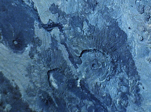
Dubbi, located east of the Erta Ale Range and south of the crystalline basement rocks of the Danakil Alps, is a large volcanic massif that rises above the western shore of the Red Sea. About 20 small cinder cones are located at the summit, and extensive basaltic lava fields to the north and NE, known as the Edd lava field, cover an area of 2700 km2 and reach the Red Sea coast. The two most-recent eruptive centers are fissure systems that extend NW-SE and NNE-SSW. The former produced lava flows that reached the Red Sea in 1400 CE. The second created 19 small craters at the summit in 1861. Ash fell more than 300 km from the volcano. Two villages were destroyed and more than 100 people were killed during Africa's largest eruption in historical time. Lava flows from the 1861 eruption traveled as far as 22 km and reached the coast.
— Smithsonian Institution, Global Volcanism Program
4 Recorded Eruptions
| Year | VEI | Type | Area |
|---|---|---|---|
| 1900 | — | Uncertain Eruption | — |
| 1863 | 2 | Uncertain Eruption | — |
| 1861 | 3 | Confirmed Eruption | — |
| 1400 | 2 | Confirmed Eruption | — |
Real-Time Data
Frequently Asked Questions About Dubbi
Is Dubbi an active volcano?+
Dubbi is classified as active based on credible evidence of past eruptions. Although its last known eruption was in 1861 CE, volcanologists consider it capable of erupting again.
When did Dubbi last erupt?+
The most recent recorded eruption of Dubbi occurred in 1900 CE. The eruption was classified as a "Uncertain Eruption." Dubbi has 4 recorded eruptions in total.
How high is Dubbi?+
Dubbi has a summit elevation of 1,625 meters (5,332 feet) above sea level. At 1,625 meters, it is a moderately sized volcanic peak, roughly comparable to Mount Vesuvius (1,281m).
What type of volcano is Dubbi?+
Dubbi is classified as a Stratovolcano. Stratovolcanoes (also called composite volcanoes) are steep, conical volcanoes built up by many layers of hardened lava, tephra, and volcanic ash. They are among the most common and dangerous types, known for explosive eruptions.
Where is Dubbi located?+
Dubbi is located in Eritrea, in the Eastern Africa Volcanic Regions. More specifically, it lies within the Afar Rift Volcanic Province. Its exact coordinates are 13.579° latitude, 41.809° longitude.
Is it safe to visit Dubbi?+
Dubbi can generally be visited, but as with any volcano, visitors should check local conditions and any advisory notices before traveling. Eritrea may have specific regulations for accessing volcanic areas. Guided tours are often the safest and most informative way to experience a volcano.