About Lewotobi
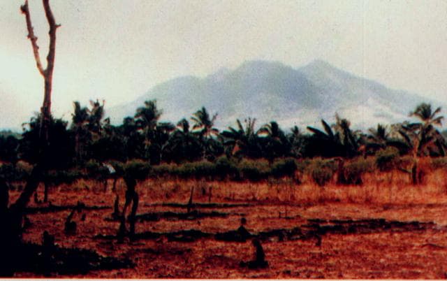
Lewotobi is a stratovolcano(es) rising to 1,703 meters (5,588 feet) in Indonesia's Sunda-Banda Volcanic Regions. The volcano is currently active, with its most recent eruption in 2025 CE. The volcano has produced 20 recorded eruptions, with a maximum Volcanic Explosivity Index (VEI) of 3.
Geography & Climate
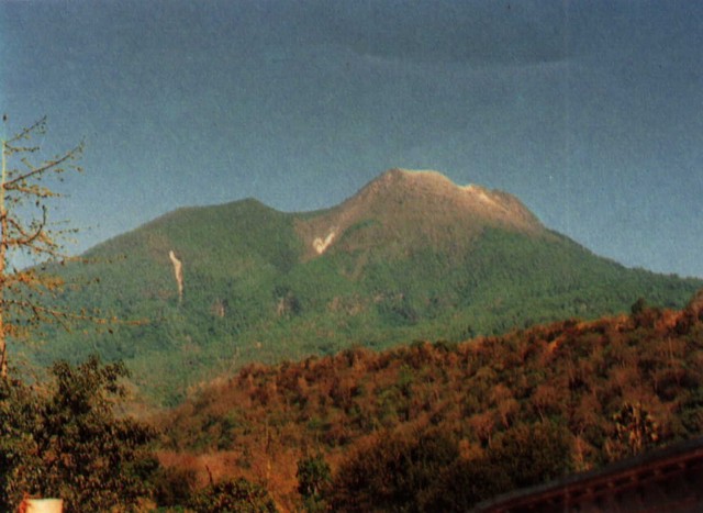
Lewotobi is located in Indonesia, within the Sunda Volcanic Arc of the broader Sunda-Banda Volcanic Regions. Situated at 8.54° S, 122.78° E in the Southern Hemisphere, the volcano lies within a tropical climate zone. With a summit elevation of 1,703 meters above sea level, Lewotobi is a moderately sized peak that remains accessible to hikers and researchers for much of the year. The volcanic landform is characterized as a composite, which describes the physical shape and structure of the volcanic edifice as observed from the surface.
Geological Context
Lewotobi sits in a subduction zone, where one tectonic plate dives beneath another, creating intense heat and pressure that generates magma. Subduction zones are responsible for many of the world's most explosive volcanoes and deadliest eruptions. For communities in Indonesia near Lewotobi, this tectonic setting means the volcano is capable of producing powerful explosive eruptions, pyroclastic flows, and lahars that can threaten populated areas within tens of kilometers of the summit. The dominant rock type is andesite / basaltic andesite, a dark, fine-grained volcanic rock that forms from rapidly cooling, low-viscosity lava. Basaltic eruptions tend to be less explosive and produce fluid lava flows that can travel long distances. While less immediately dangerous than explosive eruptions, basaltic lava flows can destroy structures and infrastructure in their path, and volcanic gases released during these eruptions can affect air quality over a wide area.
Eruption History Summary
Lewotobi has 20 recorded eruptions in the geological database, spanning from 1868 CE to 2023 CE. The most powerful recorded event was a severe eruption capable of regional ash fall and pyroclastic flows in 1932 CE, reaching VEI 3 on the Volcanic Explosivity Index. Notable eruptions include 1932 CE (VEI 3), 1907 CE (VEI 3). With an average interval of roughly 8 years between eruptions over a span of 155 years, this is one of the more frequently active volcanoes in the database. This persistent activity suggests a robust and well-supplied magma system beneath the volcano. With eruptive activity as recently as 2023 CE, Lewotobi remains an actively monitored volcano.
Significance
With a maximum recorded VEI of 3, Lewotobi has produced eruptions capable of generating pyroclastic flows and significant ash fall in the surrounding area. While not among the largest eruptions globally, VEI 3 events pose serious hazards to local populations and can disrupt regional air travel. Its 20 recorded eruptions make it one of the most prolific volcanoes in our database, reflecting a persistent and well-documented eruptive history that has provided volcanologists with extensive data for understanding eruption patterns and forecasting future activity. Given its recent activity, Lewotobi is closely monitored by geological survey organizations to provide early warning of future unrest.
GVP Reference Summary
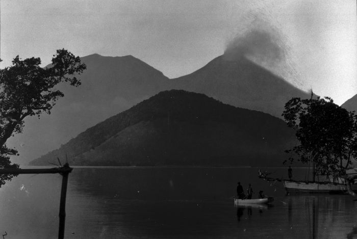
The Lewotobi edifice in eastern Flores Island is composed of the two adjacent Lewotobi Laki-laki and Lewotobi Perempuan stratovolcanoes (the "husband and wife"). Their summits are less than 2 km apart along a NW-SE line. The conical Laki-laki to the NW has been frequently active during the 19th and 20th centuries, while the taller and broader Perempuan has had observed eruptions in 1921 and 1935. Small lava domes have grown during the 20th century in both of the summit craters, which are open to the north. A prominent cone, Iliwokar, occurs on the E flank of Perampuan.
— Smithsonian Institution, Global Volcanism Program
20 Recorded Eruptions
| Year | VEI | Type | Area |
|---|---|---|---|
| 2023 | 2 | Confirmed Eruption | — |
| 2014 | 2 | Uncertain Eruption | — |
| 2003 | 2 | Confirmed Eruption | Lewotobi Lakilaki |
| 2002 | 1 | Confirmed Eruption | Lewotobi Lakilaki |
| 1999 | 2 | Confirmed Eruption | Lewotobi Lakilaki |
| 1991 | 1 | Confirmed Eruption | Lewotobi Lakilaki |
| 1990 | 1 | Confirmed Eruption | Lewotabi Lakilaki |
| 1971 | 2 | Confirmed Eruption | Lewotobi Lakilaki |
| 1970 | 2 | Confirmed Eruption | Lewotobi Lakilaki |
| 1968 | 2 | Confirmed Eruption | Lewotobi Lakilaki |
| 1939 | 2 | Confirmed Eruption | Lewotobi Lakilaki |
| 1935 | 2 | Confirmed Eruption | Lewetobi Perempuan |
| 1932 | 3 | Confirmed Eruption | Lewotobi Lakilaki |
| 1921 | 2 | Confirmed Eruption | Lewotobi Perempuan |
| 1914 | 2 | Confirmed Eruption | Lewotobi Lakilaki |
| 1909 | 2 | Confirmed Eruption | Lewotobi Lakilaki |
| 1907 | 3 | Confirmed Eruption | Lewotobi Lakilaki |
| 1889 | 2 | Confirmed Eruption | Lewotobi Lakilaki |
| 1869 | 2 | Confirmed Eruption | Lewotobi Lakilaki |
| 1868 | 2 | Confirmed Eruption | Lewotobi Lakilaki |
Real-Time Data
Frequently Asked Questions About Lewotobi
Is Lewotobi an active volcano?+
Yes, Lewotobi is considered an active volcano. Its most recent eruption was in 2025 CE. The volcano is monitored by geological agencies, and its activity status is based on observed eruptions within recorded history.
When did Lewotobi last erupt?+
The most recent recorded eruption of Lewotobi occurred in 2023 CE with a Volcanic Explosivity Index (VEI) of 2. The eruption was classified as a "Confirmed Eruption." Lewotobi has 20 recorded eruptions in total.
How high is Lewotobi?+
Lewotobi has a summit elevation of 1,703 meters (5,588 feet) above sea level. At 1,703 meters, it is a moderately sized volcanic peak, roughly comparable to Mount Vesuvius (1,281m).
What type of volcano is Lewotobi?+
Lewotobi is classified as a Stratovolcano(es). Stratovolcano(es) volcanoes have distinct geological characteristics that set them apart from other volcanic types.
Where is Lewotobi located?+
Lewotobi is located in Indonesia, in the Sunda-Banda Volcanic Regions. More specifically, it lies within the Sunda Volcanic Arc. Its exact coordinates are -8.542° latitude, 122.775° longitude.
Is it safe to visit Lewotobi?+
Visiting Lewotobi requires checking current volcanic activity and alert levels. As an active volcano with eruptions as recent as 2025 CE, conditions can change rapidly. Always consult local geological authorities and follow official warnings before visiting. Many active volcanoes have designated safe viewing areas and guided tour options.