About Tair, Jebel at
Tair, Jebel at is a stratovolcano rising to 244 meters (801 feet) in Yemen's Eastern Africa Volcanic Regions. It has been active in recent decades, with its last eruption in 2008 CE. The volcano has produced 5 recorded eruptions, with a maximum Volcanic Explosivity Index (VEI) of 3.
Geography & Climate
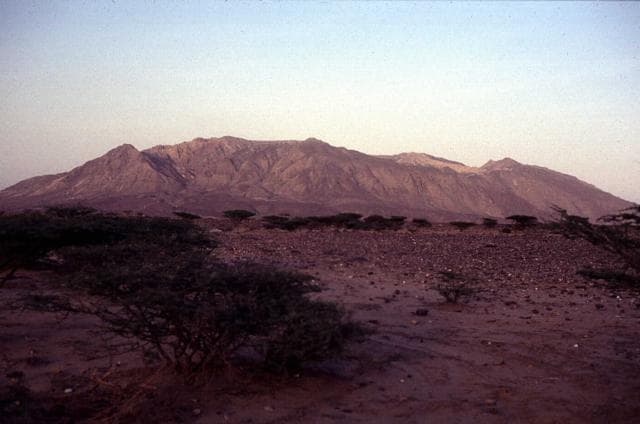
Tair, Jebel at is located in Yemen, within the Red Sea Rift Volcanic Province of the broader Eastern Africa Volcanic Regions. Situated at 15.55° N, 41.83° E in the Northern Hemisphere, the volcano lies within a tropical climate zone. At just 244 meters above sea level, Tair, Jebel at is a relatively low-elevation volcanic feature. Despite its modest height, it remains an active geological formation with the same underlying magmatic processes as its taller counterparts. The volcanic landform is characterized as a composite, which describes the physical shape and structure of the volcanic edifice as observed from the surface.
Geological Context
Tair, Jebel at is situated along a rift zone, where tectonic plates are pulling apart. As the crust thins and fractures, magma rises to fill the gap, creating volcanic activity. Rift volcanism typically produces more fluid lava flows rather than explosive blasts, which means communities near Tair, Jebel at in Yemen generally face slower-moving hazards like lava flows and ground fissures rather than sudden pyroclastic events. However, rift volcanoes can still generate significant ash emissions and gas releases that affect local air quality. The dominant rock type is trachybasalt / tephrite basanite, a dark, fine-grained volcanic rock that forms from rapidly cooling, low-viscosity lava. Basaltic eruptions tend to be less explosive and produce fluid lava flows that can travel long distances. While less immediately dangerous than explosive eruptions, basaltic lava flows can destroy structures and infrastructure in their path, and volcanic gases released during these eruptions can affect air quality over a wide area.
Eruption History Summary
Tair, Jebel at has 5 recorded eruptions in the geological database, spanning from 1750 CE to 2007 CE. The most powerful recorded event was a severe eruption capable of regional ash fall and pyroclastic flows in 2007 CE, reaching VEI 3 on the Volcanic Explosivity Index. This eruption frequency indicates a moderately active volcanic system with periodic reawakenings. With eruptive activity as recently as 2007 CE, Tair, Jebel at remains an actively monitored volcano.
Significance
With a maximum recorded VEI of 3, Tair, Jebel at has produced eruptions capable of generating pyroclastic flows and significant ash fall in the surrounding area. While not among the largest eruptions globally, VEI 3 events pose serious hazards to local populations and can disrupt regional air travel. With 5 recorded eruptions on file, Tair, Jebel at has enough documented activity to help scientists identify patterns in its eruptive behavior. Given its recent activity, Tair, Jebel at is closely monitored by geological survey organizations to provide early warning of future unrest.
GVP Reference Summary
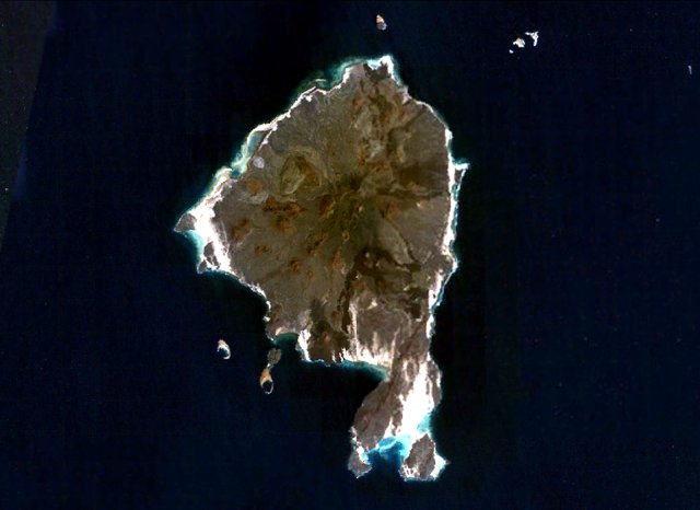
The basaltic Jebel at Tair volcano rises from 1,200 m depth in the south-central Red Sea, forming an oval-shaped island about 3 km long. It is the northernmost known Holocene volcano in the Red Sea and lies SW of the Farisan Islands. Youthful basaltic pahoehoe lava flows from the steep-sided central vent, Jebel Duchan, cover most of the island, draping a circular cliff cut by wave erosion of an older edifice and extending beyond it to form a flat coastal plain. Pyroclastic cones are located along the NW and S coasts, and fumarolic activity occurs from two uneroded scoria cones at the summit. Radial fissures extend from the summit, some of which were the sources of lava flows. Explosive eruptions were reported in the 18th and 19th centuries, prior to an eruption in 2007-2008.
— Smithsonian Institution, Global Volcanism Program
5 Recorded Eruptions
| Year | VEI | Type | Area |
|---|---|---|---|
| 2007 | 3 | Confirmed Eruption | — |
| 1883 | 2 | Confirmed Eruption | — |
| 1863 | 2 | Confirmed Eruption | — |
| 1833 | 2 | Confirmed Eruption | — |
| 1750 | 2 | Confirmed Eruption | — |
Real-Time Data
Frequently Asked Questions About Tair, Jebel at
Is Tair, Jebel at an active volcano?+
Yes, Tair, Jebel at is considered an active volcano. Its most recent eruption was in 2008 CE. The volcano is monitored by geological agencies, and its activity status is based on observed eruptions within recorded history.
When did Tair, Jebel at last erupt?+
The most recent recorded eruption of Tair, Jebel at occurred in 2007 CE with a Volcanic Explosivity Index (VEI) of 3. The eruption was classified as a "Confirmed Eruption." Tair, Jebel at has 5 recorded eruptions in total.
How high is Tair, Jebel at?+
Tair, Jebel at has a summit elevation of 244 meters (801 feet) above sea level. At 244 meters, it is a relatively low-elevation volcano.
What type of volcano is Tair, Jebel at?+
Tair, Jebel at is classified as a Stratovolcano. Stratovolcanoes (also called composite volcanoes) are steep, conical volcanoes built up by many layers of hardened lava, tephra, and volcanic ash. They are among the most common and dangerous types, known for explosive eruptions.
Where is Tair, Jebel at located?+
Tair, Jebel at is located in Yemen, in the Eastern Africa Volcanic Regions. More specifically, it lies within the Red Sea Rift Volcanic Province. Its exact coordinates are 15.550° latitude, 41.830° longitude.
Is it safe to visit Tair, Jebel at?+
Visiting Tair, Jebel at requires checking current volcanic activity and alert levels. As an active volcano with eruptions as recent as 2008 CE, conditions can change rapidly. Always consult local geological authorities and follow official warnings before visiting. Many active volcanoes have designated safe viewing areas and guided tour options.