About Agung
Agung is a stratovolcano rising to 2,997 meters (9,833 feet) in Indonesia's Sunda-Banda Volcanic Regions. The volcano is currently active, with its most recent eruption in 2022 CE. The volcano has produced 7 recorded eruptions, with a maximum Volcanic Explosivity Index (VEI) of 5.
Geography & Climate
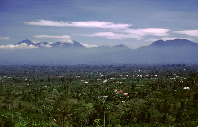
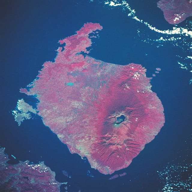
Agung is located in Indonesia, within the Sunda Volcanic Arc of the broader Sunda-Banda Volcanic Regions. Situated at 8.34° S, 115.51° E in the Southern Hemisphere, the volcano lies within a tropical climate zone. At 2,997 meters above sea level, Agung rises above the surrounding terrain into montane or subalpine conditions. The elevation creates distinct ecological zones along its flanks, from forested lower slopes to exposed rocky terrain near the summit. The volcanic landform is characterized as a composite, which describes the physical shape and structure of the volcanic edifice as observed from the surface.
Geological Context
Agung sits in a subduction zone, where one tectonic plate dives beneath another, creating intense heat and pressure that generates magma. Subduction zones are responsible for many of the world's most explosive volcanoes and deadliest eruptions. For communities in Indonesia near Agung, this tectonic setting means the volcano is capable of producing powerful explosive eruptions, pyroclastic flows, and lahars that can threaten populated areas within tens of kilometers of the summit. The dominant rock type is andesite / basaltic andesite, a dark, fine-grained volcanic rock that forms from rapidly cooling, low-viscosity lava. Basaltic eruptions tend to be less explosive and produce fluid lava flows that can travel long distances. While less immediately dangerous than explosive eruptions, basaltic lava flows can destroy structures and infrastructure in their path, and volcanic gases released during these eruptions can affect air quality over a wide area.
Eruption History Summary
Agung has 7 recorded eruptions in the geological database, spanning from 1808 CE to 2022 CE. The most powerful recorded event was a paroxysmal eruption with devastating regional consequences in 1963 CE, reaching VEI 5 on the Volcanic Explosivity Index. Notable eruptions include 2017 CE (VEI 3), 1963 CE (VEI 5), 1843 CE (VEI 5). This eruption frequency indicates a moderately active volcanic system with periodic reawakenings. With eruptive activity as recently as 2022 CE, Agung remains an actively monitored volcano.
Significance
With a maximum recorded VEI of 5, Agung has demonstrated the capacity for paroxysmal eruptions comparable to the 1980 eruption of Mount St. Helens. Eruptions of this scale can devastate areas within 20-30 kilometers and produce ash fall that disrupts aviation and agriculture across hundreds of kilometers. With 7 recorded eruptions on file, Agung has enough documented activity to help scientists identify patterns in its eruptive behavior. Given its recent activity, Agung is closely monitored by geological survey organizations to provide early warning of future unrest.
GVP Reference Summary
Symmetrical Agung stratovolcano, Bali's highest and most sacred mountain, towers over the eastern end of the island. The volcano, whose name means "Paramount," rises above the SE rim of the Batur caldera, and the northern and southern flanks extend to the coast. The summit area extends 1.5 km E-W, with the high point on the W and a steep-walled 800-m-wide crater on the E. The Pawon cone is located low on the SE flank. Only a few eruptions dating back to the early 19th century have been recorded in historical time. The 1963-64 eruption, one of the largest in the 20th century, produced voluminous ashfall along with devastating pyroclastic flows and lahars that caused extensive damage and many fatalities.
— Smithsonian Institution, Global Volcanism Program
7 Recorded Eruptions
| Year | VEI | Type | Area |
|---|---|---|---|
| 2022 | 1 | Confirmed Eruption | — |
| 2022 | 1 | Uncertain Eruption | — |
| 2017 | 3 | Confirmed Eruption | Summit crater |
| 1963 | 5 | Confirmed Eruption | — |
| 1843 | 5 | Confirmed Eruption | — |
| 1821 | 2 | Uncertain Eruption | — |
| 1808 | 2 | Confirmed Eruption | — |
Real-Time Data
Frequently Asked Questions About Agung
Is Agung an active volcano?+
Yes, Agung is considered an active volcano. Its most recent eruption was in 2022 CE. The volcano is monitored by geological agencies, and its activity status is based on observed eruptions within recorded history.
When did Agung last erupt?+
The most recent recorded eruption of Agung occurred in 2022 CE with a Volcanic Explosivity Index (VEI) of 1. The eruption was classified as a "Confirmed Eruption." Agung has 7 recorded eruptions in total.
How high is Agung?+
Agung has a summit elevation of 2,997 meters (9,833 feet) above sea level. At 2,997 meters, it is comparable in height to many significant mountain peaks and stands well above the tree line.
What type of volcano is Agung?+
Agung is classified as a Stratovolcano. Stratovolcanoes (also called composite volcanoes) are steep, conical volcanoes built up by many layers of hardened lava, tephra, and volcanic ash. They are among the most common and dangerous types, known for explosive eruptions.
Where is Agung located?+
Agung is located in Indonesia, in the Sunda-Banda Volcanic Regions. More specifically, it lies within the Sunda Volcanic Arc. Its exact coordinates are -8.343° latitude, 115.508° longitude.
Is it safe to visit Agung?+
Visiting Agung requires checking current volcanic activity and alert levels. As an active volcano with eruptions as recent as 2022 CE, conditions can change rapidly. Always consult local geological authorities and follow official warnings before visiting. Many active volcanoes have designated safe viewing areas and guided tour options.