About Sundoro
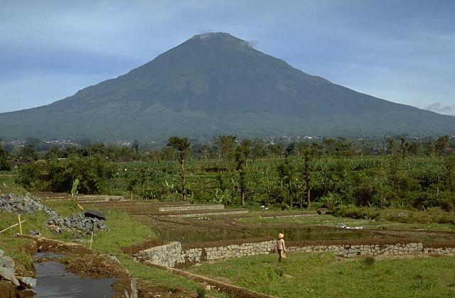
Sundoro is a stratovolcano rising to 3,149 meters (10,332 feet) in Indonesia's Sunda-Banda Volcanic Regions. It last erupted in 1971 CE, and volcanologists consider it an active volcanic system. The volcano has produced 11 recorded eruptions, with a maximum Volcanic Explosivity Index (VEI) of 2.
Geography & Climate
Sundoro is located in Indonesia, within the Sunda Volcanic Arc of the broader Sunda-Banda Volcanic Regions. Situated at 7.30° S, 110.00° E in the Southern Hemisphere, the volcano lies within a tropical climate zone. At 3,149 meters above sea level, Sundoro rises above the surrounding terrain into montane or subalpine conditions. The elevation creates distinct ecological zones along its flanks, from forested lower slopes to exposed rocky terrain near the summit. The volcanic landform is characterized as a composite, which describes the physical shape and structure of the volcanic edifice as observed from the surface.
Geological Context
Sundoro sits in a subduction zone, where one tectonic plate dives beneath another, creating intense heat and pressure that generates magma. Subduction zones are responsible for many of the world's most explosive volcanoes and deadliest eruptions. For communities in Indonesia near Sundoro, this tectonic setting means the volcano is capable of producing powerful explosive eruptions, pyroclastic flows, and lahars that can threaten populated areas within tens of kilometers of the summit. The dominant rock type is andesite / basaltic andesite, a dark, fine-grained volcanic rock that forms from rapidly cooling, low-viscosity lava. Basaltic eruptions tend to be less explosive and produce fluid lava flows that can travel long distances. While less immediately dangerous than explosive eruptions, basaltic lava flows can destroy structures and infrastructure in their path, and volcanic gases released during these eruptions can affect air quality over a wide area.
Eruption History Summary
Sundoro has 11 recorded eruptions in the geological database, spanning from 230 CE to 1971 CE. The most powerful recorded event was an explosive event producing ash plumes up to several kilometers in 1971 CE, reaching VEI 2 on the Volcanic Explosivity Index. This level of eruptive frequency indicates a persistently active volcanic system that warrants ongoing monitoring. The most recent eruption in 1971 CE places this volcano within the modern era of volcanological observation.
Significance
With 11 recorded eruptions, Sundoro has a substantial eruptive history that provides valuable data for understanding volcanic behavior and assessing future hazards in the Sunda-Banda Volcanic Regions region. Given its recent activity, Sundoro is closely monitored by geological survey organizations to provide early warning of future unrest.
GVP Reference Summary
Gunung Sundoro, in central Java, is located between the Dieng complex to the NW and Sumbing volcano to the SE. The large Kembang cone is about 2.5 km from the summit on the SW flank. A small lava dome occupies the summit crater, and numerous phreatic explosion vents are present in the summit area. Lava flows extend in all directions from the summit crater. Deposits of a large debris avalanche are located below the NE flank. Pyroclastic-flow deposits dated at 1,720 years before present extend as far as 13 km from the summit. Recorded eruptions typically have consisted of mild-to-moderate phreatic explosions, mostly from the summit crater. Flank vents were also active in 1882 and 1903.
— Smithsonian Institution, Global Volcanism Program
11 Recorded Eruptions
| Year | VEI | Type | Area |
|---|---|---|---|
| 1971 | 2 | Confirmed Eruption | — |
| 1906 | 2 | Confirmed Eruption | Summit crater K5 |
| 1903 | 2 | Confirmed Eruption | Upper NE and SW flanks (2850-2980 m) |
| 1902 | 1 | Confirmed Eruption | — |
| 1887 | 2 | Confirmed Eruption | — |
| 1883 | 2 | Confirmed Eruption | — |
| 1882 | 2 | Confirmed Eruption | Summit, NW and NE flanks |
| 1818 | 2 | Confirmed Eruption | — |
| 1806 | 2 | Confirmed Eruption | — |
| 470 | — | Confirmed Eruption | — |
| 230 | — | Confirmed Eruption | — |
Real-Time Data
Frequently Asked Questions About Sundoro
Is Sundoro an active volcano?+
Yes, Sundoro is considered an active volcano. Its most recent eruption was in 1971 CE. The volcano is monitored by geological agencies, and its activity status is based on observed eruptions within recorded history.
When did Sundoro last erupt?+
The most recent recorded eruption of Sundoro occurred in 1971 CE with a Volcanic Explosivity Index (VEI) of 2. The eruption was classified as a "Confirmed Eruption." Sundoro has 11 recorded eruptions in total.
How high is Sundoro?+
Sundoro has a summit elevation of 3,149 meters (10,332 feet) above sea level. At 3,149 meters, it is comparable in height to many significant mountain peaks and stands well above the tree line.
What type of volcano is Sundoro?+
Sundoro is classified as a Stratovolcano. Stratovolcanoes (also called composite volcanoes) are steep, conical volcanoes built up by many layers of hardened lava, tephra, and volcanic ash. They are among the most common and dangerous types, known for explosive eruptions.
Where is Sundoro located?+
Sundoro is located in Indonesia, in the Sunda-Banda Volcanic Regions. More specifically, it lies within the Sunda Volcanic Arc. Its exact coordinates are -7.301° latitude, 109.997° longitude.
Is it safe to visit Sundoro?+
Visiting Sundoro requires checking current volcanic activity and alert levels. As an active volcano with eruptions as recent as 1971 CE, conditions can change rapidly. Always consult local geological authorities and follow official warnings before visiting. Many active volcanoes have designated safe viewing areas and guided tour options.