About Patah
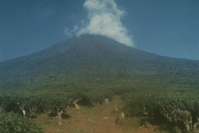
Patah is a stratovolcano? rising to 2,836 meters (9,305 feet) in Indonesia's Sunda-Banda Volcanic Regions. No historical eruptions have been recorded, though the volcano is classified based on geological evidence of past activity.
Geography & Climate
Patah is located in Indonesia, within the Sunda Volcanic Arc of the broader Sunda-Banda Volcanic Regions. Situated at 4.26° S, 103.31° E in the Southern Hemisphere, the volcano lies within a tropical climate zone. At 2,836 meters above sea level, Patah rises above the surrounding terrain into montane or subalpine conditions. The elevation creates distinct ecological zones along its flanks, from forested lower slopes to exposed rocky terrain near the summit. The volcanic landform is characterized as a composite, which describes the physical shape and structure of the volcanic edifice as observed from the surface.
Geological Context
Patah sits in a subduction zone, where one tectonic plate dives beneath another, creating intense heat and pressure that generates magma. Subduction zones are responsible for many of the world's most explosive volcanoes and deadliest eruptions. For communities in Indonesia near Patah, this tectonic setting means the volcano is capable of producing powerful explosive eruptions, pyroclastic flows, and lahars that can threaten populated areas within tens of kilometers of the summit. The dominant rock type is no data (checked), which influences the viscosity of the magma and, consequently, the style of eruptions this volcano produces. Rock chemistry is one of the most important factors in determining whether a volcano erupts explosively or effusively.
GVP Reference Summary
Patah is a heavily forested, dissected Quaternary volcano SE of Dempo volcano. The age of its latest eruptions is not known, although on 1 May 1989 a possible new 150-m-wide crater with active fumaroles was observed by a cargo aircraft pilot in a heavily forested area on the side of a small cone about 3 km SE of Gunung Patah. The exact date of its formation, and its geologic relationship to Patah are uncertain. A crater lake at the summit of another peak, Bukit Belirang (Sulfur Hill), is located 1.5 km S of the fumaroles.
— Smithsonian Institution, Global Volcanism Program
0 Recorded Eruptions
No eruption records available for Patah.
Real-Time Data
Frequently Asked Questions About Patah
Is Patah an active volcano?+
Patah is not currently classified as active. Its activity evidence is listed as "Unrest / Holocene." No recorded eruptions have been documented. However, no volcano is ever considered permanently extinct.
How high is Patah?+
Patah has a summit elevation of 2,836 meters (9,305 feet) above sea level. At 2,836 meters, it is comparable in height to many significant mountain peaks and stands well above the tree line.
What type of volcano is Patah?+
Patah is classified as a Stratovolcano?. Stratovolcano? volcanoes have distinct geological characteristics that set them apart from other volcanic types.
Where is Patah located?+
Patah is located in Indonesia, in the Sunda-Banda Volcanic Regions. More specifically, it lies within the Sunda Volcanic Arc. Its exact coordinates are -4.257° latitude, 103.306° longitude.
Is it safe to visit Patah?+
Patah can generally be visited, but as with any volcano, visitors should check local conditions and any advisory notices before traveling. Indonesia may have specific regulations for accessing volcanic areas. Guided tours are often the safest and most informative way to experience a volcano.