About Kuwae
Kuwae is a caldera rising to -2 meters (-7 feet) in Vanuatu's Southwestern Pacific Volcanic Regions. It last erupted in 1974 CE, and volcanologists consider it an active volcanic system. The volcano has produced 18 recorded eruptions, with a maximum Volcanic Explosivity Index (VEI) of 3.
Geography & Climate
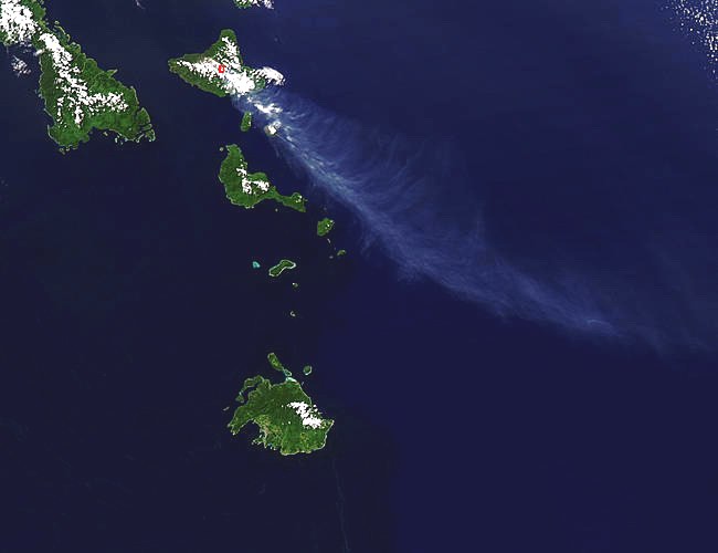
Kuwae is located in Vanuatu, within the Vanuatu Volcanic Arc of the broader Southwestern Pacific Volcanic Regions. Situated at 16.83° S, 168.52° E in the Southern Hemisphere, the volcano lies within a tropical climate zone. With an elevation of -2 meters — below sea level — Kuwae is a submarine or submerged volcanic feature. Submarine volcanoes make up the majority of Earth's volcanic activity, though most eruptions go unobserved beneath the ocean surface. The volcanic landform is characterized as a caldera, which describes the physical shape and structure of the volcanic edifice as observed from the surface.
Geological Context
Kuwae sits in a subduction zone, where one tectonic plate dives beneath another, creating intense heat and pressure that generates magma. Subduction zones are responsible for many of the world's most explosive volcanoes and deadliest eruptions. For communities in Vanuatu near Kuwae, this tectonic setting means the volcano is capable of producing powerful explosive eruptions, pyroclastic flows, and lahars that can threaten populated areas within tens of kilometers of the summit. The dominant rock type is basalt / picro-basalt, a dark, fine-grained volcanic rock that forms from rapidly cooling, low-viscosity lava. Basaltic eruptions tend to be less explosive and produce fluid lava flows that can travel long distances. While less immediately dangerous than explosive eruptions, basaltic lava flows can destroy structures and infrastructure in their path, and volcanic gases released during these eruptions can affect air quality over a wide area.
Eruption History Summary
Kuwae has 18 recorded eruptions in the geological database, spanning from 1425 CE to 1980 CE. The most powerful recorded event was a severe eruption capable of regional ash fall and pyroclastic flows in 1949 CE, reaching VEI 3 on the Volcanic Explosivity Index. Notable eruptions include 1949 CE (VEI 3), 1949 CE (VEI 3). This level of eruptive frequency indicates a persistently active volcanic system that warrants ongoing monitoring. The most recent eruption in 1980 CE places this volcano within the modern era of volcanological observation.
Significance
With a maximum recorded VEI of 3, Kuwae has produced eruptions capable of generating pyroclastic flows and significant ash fall in the surrounding area. While not among the largest eruptions globally, VEI 3 events pose serious hazards to local populations and can disrupt regional air travel. With 18 recorded eruptions, Kuwae has a substantial eruptive history that provides valuable data for understanding volcanic behavior and assessing future hazards in the Southwestern Pacific Volcanic Regions region. Given its recent activity, Kuwae is closely monitored by geological survey organizations to provide early warning of future unrest.
GVP Reference Summary
The largely submarine Kuwae caldera occupies the area between Epi and Tongoa islands. The 6 x 12 km caldera contains two basins that cut the NW end of Tongoa Island and the flank of the Tavani Ruru volcano on the SE peninsula of Epi Island. Native legends and radiocarbon dates from pyroclastic-flow deposits have been correlated with a 1452 CE ice-core peak thought to be associated with collapse of Kuwae caldera; however, others considered the deposits to be of smaller-scale eruptions and the ice-core peak to be associated with another unknown major South Pacific eruption. The submarine Karua cone in the east-central part of the caldera has formed several ephemeral islands since it was first observed in eruption during 1897.
— Smithsonian Institution, Global Volcanism Program
18 Recorded Eruptions
| Year | VEI | Type | Area |
|---|---|---|---|
| 1980 | 0 | Uncertain Eruption | Karua |
| 1979 | 0 | Uncertain Eruption | Karua |
| 1977 | 0 | Uncertain Eruption | Karua |
| 1974 | 0 | Confirmed Eruption | Karua |
| 1973 | 0 | Uncertain Eruption | Karua |
| 1972 | 0 | Uncertain Eruption | Karua |
| 1971 | 2 | Confirmed Eruption | Karua |
| 1970 | 0 | Uncertain Eruption | Karua |
| 1959 | 2 | Confirmed Eruption | Karua |
| 1958 | 2 | Confirmed Eruption | Karua |
| 1953 | 1 | Confirmed Eruption | Karua |
| 1952 | 1 | Confirmed Eruption | Karua |
| 1949 | 3 | Confirmed Eruption | Karua |
| 1949 | 3 | Confirmed Eruption | Karua |
| 1948 | 2 | Confirmed Eruption | Karua |
| 1923 | 2 | Confirmed Eruption | Karua |
| 1897 | 1 | Confirmed Eruption | Karua |
| 1425 | — | Confirmed Eruption | — |
Real-Time Data
Frequently Asked Questions About Kuwae
Is Kuwae an active volcano?+
Yes, Kuwae is considered an active volcano. Its most recent eruption was in 1974 CE. The volcano is monitored by geological agencies, and its activity status is based on observed eruptions within recorded history.
When did Kuwae last erupt?+
The most recent recorded eruption of Kuwae occurred in 1980 CE with a Volcanic Explosivity Index (VEI) of 0. The eruption was classified as a "Uncertain Eruption." Kuwae has 18 recorded eruptions in total.
How high is Kuwae?+
Kuwae has a summit elevation of -2 meters (-7 feet) above sea level. With an elevation of -2 meters (below sea level), this is a submarine or submerged volcanic feature.
What type of volcano is Kuwae?+
Kuwae is classified as a Caldera. Calderas are large volcanic depressions formed when a volcano erupts so powerfully that its magma chamber collapses, creating a basin that can be kilometers wide. They are often sites of some of Earth's largest eruptions.
Where is Kuwae located?+
Kuwae is located in Vanuatu, in the Southwestern Pacific Volcanic Regions. More specifically, it lies within the Vanuatu Volcanic Arc. Its exact coordinates are -16.830° latitude, 168.523° longitude.
Is it safe to visit Kuwae?+
Visiting Kuwae requires checking current volcanic activity and alert levels. As an active volcano with eruptions as recent as 1974 CE, conditions can change rapidly. Always consult local geological authorities and follow official warnings before visiting. Many active volcanoes have designated safe viewing areas and guided tour options.