About Savo
Savo is a stratovolcano rising to 455 meters (1,493 feet) in Solomon Islands's Southwestern Pacific Volcanic Regions. Its last known eruption was in 1847 CE. The volcano has produced 4 recorded eruptions, with a maximum Volcanic Explosivity Index (VEI) of 3.
Geography & Climate
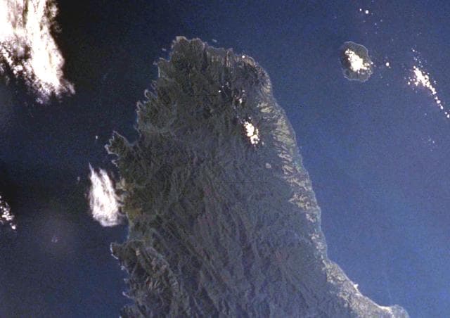
Savo is located in Solomon Islands, within the Solomon Volcanic Province of the broader Southwestern Pacific Volcanic Regions. Situated at 9.13° S, 159.81° E in the Southern Hemisphere, the volcano lies within a tropical climate zone. At just 455 meters above sea level, Savo is a relatively low-elevation volcanic feature. Despite its modest height, it remains an active geological formation with the same underlying magmatic processes as its taller counterparts. The volcanic landform is characterized as a composite, which describes the physical shape and structure of the volcanic edifice as observed from the surface.
Geological Context
Savo sits in a subduction zone, where one tectonic plate dives beneath another, creating intense heat and pressure that generates magma. Subduction zones are responsible for many of the world's most explosive volcanoes and deadliest eruptions. For communities in Solomon Islands near Savo, this tectonic setting means the volcano is capable of producing powerful explosive eruptions, pyroclastic flows, and lahars that can threaten populated areas within tens of kilometers of the summit. The dominant rock type is andesite / basaltic andesite, a dark, fine-grained volcanic rock that forms from rapidly cooling, low-viscosity lava. Basaltic eruptions tend to be less explosive and produce fluid lava flows that can travel long distances. While less immediately dangerous than explosive eruptions, basaltic lava flows can destroy structures and infrastructure in their path, and volcanic gases released during these eruptions can affect air quality over a wide area.
Eruption History Summary
Savo has 4 recorded eruptions in the geological database, spanning from 1568 CE to 1865 CE. The most powerful recorded event was a severe eruption capable of regional ash fall and pyroclastic flows in 1835 CE, reaching VEI 3 on the Volcanic Explosivity Index. Notable eruptions include 1835 CE (VEI 3), 1568 CE (VEI 3). These eruptions span roughly 297 years of volcanic history.
Significance
With a maximum recorded VEI of 3, Savo has produced eruptions capable of generating pyroclastic flows and significant ash fall in the surrounding area. While not among the largest eruptions globally, VEI 3 events pose serious hazards to local populations and can disrupt regional air travel.
GVP Reference Summary
The 6 x 7 km island of Savo, off the NE coast of Guadalcanal Island, consists of a forested andesitic-to-dacitic stratovolcano with a shallow, elliptical 1 x 1.5 km summit crater. Young lava domes are located on the crater floor and the NE rim, and older domes occur on the flanks. Pyroclastic flows and mudflows traveled down valleys from the summit crater to form debris fans along the coast. Thermal areas located in the summit crater, the S to SE flanks, and offshore include areas of steaming ground, fumaroles, small geysers, and hot springs. Spanish explorers observed the first recorded eruption in 1568. Pyroclastic flows during the climactic phase killed almost all inhabitants of the island, and oral traditions also note the expansion of the island on the northern side. Other eruptive episodes occurred during the mid-17th century and during the 1830s to 1840s.
— Smithsonian Institution, Global Volcanism Program
4 Recorded Eruptions
| Year | VEI | Type | Area |
|---|---|---|---|
| 1865 | — | Uncertain Eruption | — |
| 1835 | 3 | Confirmed Eruption | — |
| 1650 | — | Confirmed Eruption | — |
| 1568 | 3 | Confirmed Eruption | NE crater margin |
Real-Time Data
Frequently Asked Questions About Savo
Is Savo an active volcano?+
Savo is classified as active based on credible evidence of past eruptions. Although its last known eruption was in 1847 CE, volcanologists consider it capable of erupting again.
When did Savo last erupt?+
The most recent recorded eruption of Savo occurred in 1865 CE. The eruption was classified as a "Uncertain Eruption." Savo has 4 recorded eruptions in total.
How high is Savo?+
Savo has a summit elevation of 455 meters (1,493 feet) above sea level. At 455 meters, it is a relatively low-elevation volcano.
What type of volcano is Savo?+
Savo is classified as a Stratovolcano. Stratovolcanoes (also called composite volcanoes) are steep, conical volcanoes built up by many layers of hardened lava, tephra, and volcanic ash. They are among the most common and dangerous types, known for explosive eruptions.
Where is Savo located?+
Savo is located in Solomon Islands, in the Southwestern Pacific Volcanic Regions. More specifically, it lies within the Solomon Volcanic Province. Its exact coordinates are -9.132° latitude, 159.812° longitude.
Is it safe to visit Savo?+
Savo can generally be visited, but as with any volcano, visitors should check local conditions and any advisory notices before traveling. Solomon Islands may have specific regulations for accessing volcanic areas. Guided tours are often the safest and most informative way to experience a volcano.
