Managlase Plateau
Volcanic field · 1,342m · Papua New Guinea
About Managlase Plateau
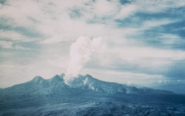
Managlase Plateau is a volcanic field rising to 1,342 meters (4,403 feet) in Papua New Guinea's Southwestern Pacific Volcanic Regions. No historical eruptions have been recorded, though the volcano is classified based on geological evidence of past activity.
Geography & Climate
Managlase Plateau is located in Papua New Guinea, within the Trobriand Volcanic Province of the broader Southwestern Pacific Volcanic Regions. Situated at 9.08° S, 148.33° E in the Southern Hemisphere, the volcano lies within a tropical climate zone. With a summit elevation of 1,342 meters above sea level, Managlase Plateau is a moderately sized peak that remains accessible to hikers and researchers for much of the year. The volcanic landform is characterized as a cluster, which describes the physical shape and structure of the volcanic edifice as observed from the surface.
Geological Context
Managlase Plateau sits in a subduction zone, where one tectonic plate dives beneath another, creating intense heat and pressure that generates magma. Subduction zones are responsible for many of the world's most explosive volcanoes and deadliest eruptions. For communities in Papua New Guinea near Managlase Plateau, this tectonic setting means the volcano is capable of producing powerful explosive eruptions, pyroclastic flows, and lahars that can threaten populated areas within tens of kilometers of the summit. The dominant rock type is trachybasalt / tephrite basanite, a dark, fine-grained volcanic rock that forms from rapidly cooling, low-viscosity lava. Basaltic eruptions tend to be less explosive and produce fluid lava flows that can travel long distances. While less immediately dangerous than explosive eruptions, basaltic lava flows can destroy structures and infrastructure in their path, and volcanic gases released during these eruptions can affect air quality over a wide area.
GVP Reference Summary
Thirty small volcanic centers of late-Pleistocene to Holocene age are located in SE Papua New Guinea on the Managlase Plateau, south of the Hydrographers Range and SW of the Dyke Ackland Bay. The fault-bounded plateau forms a triangular-shaped area with trachybasaltic lava cones and flows, scoria mounds, cinder cones, and explosion vents of the Uoivi Volcanics, and capped on its eastern side by rhyodacitic ash cones, lava domes, and ashflow deposits of the Manna Volcanics. The date of the most recent eruption is not known, but the trachybasaltic Kururui cinder cone and a nearby explosion crater were active within memory of nearby residents (Ruxton, 1966).
— Smithsonian Institution, Global Volcanism Program
0 Recorded Eruptions
No eruption records available for Managlase Plateau.
Real-Time Data
Frequently Asked Questions About Managlase Plateau
Is Managlase Plateau an active volcano?+
Managlase Plateau is classified as active based on credible evidence of past eruptions. Although its last known eruption was in prehistoric times, volcanologists consider it capable of erupting again.
How high is Managlase Plateau?+
Managlase Plateau has a summit elevation of 1,342 meters (4,403 feet) above sea level. At 1,342 meters, it is a moderately sized volcanic peak, roughly comparable to Mount Vesuvius (1,281m).
What type of volcano is Managlase Plateau?+
Managlase Plateau is classified as a Volcanic field. Volcanic fields consist of clusters of small volcanic vents and cinder cones spread across a region. Rather than a single central vent, eruptions can occur at many points across the field.
Where is Managlase Plateau located?+
Managlase Plateau is located in Papua New Guinea, in the Southwestern Pacific Volcanic Regions. More specifically, it lies within the Trobriand Volcanic Province. Its exact coordinates are -9.080° latitude, 148.330° longitude.
Is it safe to visit Managlase Plateau?+
Managlase Plateau can generally be visited, but as with any volcano, visitors should check local conditions and any advisory notices before traveling. Papua New Guinea may have specific regulations for accessing volcanic areas. Guided tours are often the safest and most informative way to experience a volcano.