About Tolima, Nevado del
Tolima, Nevado del is a stratovolcano rising to 5,215 meters (17,110 feet) in Colombia's South America Volcanic Regions. It last erupted in 1943 CE, and volcanologists consider it an active volcanic system. The volcano has produced 12 recorded eruptions, with a maximum Volcanic Explosivity Index (VEI) of 5.
Geography & Climate
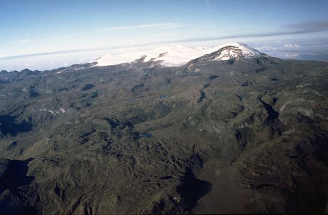
Tolima, Nevado del is located in Colombia, within the Northern Andean Volcanic Arc of the broader South America Volcanic Regions. Situated at 4.66° N, 75.33° W in the Northern Hemisphere, the volcano lies within a tropical climate zone. At 5,215 meters above sea level, Tolima, Nevado del reaches well into the permanent snow and ice zone. Glaciers and snowpack on the upper slopes create the potential for lahars — destructive volcanic mudflows — during eruptions, as heat rapidly melts ice and snow. The volcanic landform is characterized as a composite, which describes the physical shape and structure of the volcanic edifice as observed from the surface.
Geological Context
Tolima, Nevado del sits in a subduction zone, where one tectonic plate dives beneath another, creating intense heat and pressure that generates magma. Subduction zones are responsible for many of the world's most explosive volcanoes and deadliest eruptions. For communities in Colombia near Tolima, Nevado del, this tectonic setting means the volcano is capable of producing powerful explosive eruptions, pyroclastic flows, and lahars that can threaten populated areas within tens of kilometers of the summit. The dominant rock type is andesite / basaltic andesite, a dark, fine-grained volcanic rock that forms from rapidly cooling, low-viscosity lava. Basaltic eruptions tend to be less explosive and produce fluid lava flows that can travel long distances. While less immediately dangerous than explosive eruptions, basaltic lava flows can destroy structures and infrastructure in their path, and volcanic gases released during these eruptions can affect air quality over a wide area.
Eruption History Summary
Tolima, Nevado del has 12 recorded eruptions in the geological database, spanning from 7800 BCE to 1943 CE. The most powerful recorded event was a paroxysmal eruption with devastating regional consequences in 1990 BCE, reaching VEI 5 on the Volcanic Explosivity Index. Notable eruptions include 260 CE (VEI 3), 200 BCE (VEI 3), 610 BCE (VEI 3). This level of eruptive frequency indicates a persistently active volcanic system that warrants ongoing monitoring. The most recent eruption in 1943 CE places this volcano within the modern era of volcanological observation.
Significance
With a maximum recorded VEI of 5, Tolima, Nevado del has demonstrated the capacity for paroxysmal eruptions comparable to the 1980 eruption of Mount St. Helens. Eruptions of this scale can devastate areas within 20-30 kilometers and produce ash fall that disrupts aviation and agriculture across hundreds of kilometers. With 12 recorded eruptions, Tolima, Nevado del has a substantial eruptive history that provides valuable data for understanding volcanic behavior and assessing future hazards in the South America Volcanic Regions region.
GVP Reference Summary
The steep-sided, glacier-covered Nevado del Tolima volcano contrasts with the broad profile of Nevado del Ruiz to the north. The andesitic-dacitic younger Tolima formed during the past 40,000 years, rising above and largely obscuring a 3-km-wide late-Pleistocene caldera. The summit consists of a cluster of late-Pleistocene to Holocene lava domes associated with thick block-lava flows on the N and E flanks, and extensive pyroclastic-flow deposits. The summit contains a funnel-shaped crater 200-300 m deep. Holocene activity has included explosive eruptions ranging in size from moderate to Plinian, and the last major eruption took place about 3,600 years ago. Lava dome growth has produced block-and-ash flows that traveled primarily to the NE and SE. Minor explosive eruptions have been recorded in the 19th and 20th centuries.
— Smithsonian Institution, Global Volcanism Program
12 Recorded Eruptions
| Year | VEI | Type | Area |
|---|---|---|---|
| 1943 | 2 | Confirmed Eruption | — |
| 1826 | 2 | Confirmed Eruption | — |
| 1825 | 2 | Confirmed Eruption | — |
| 1822 | 2 | Confirmed Eruption | — |
| 260 | 3 | Confirmed Eruption | — |
| 200 BCE | 3 | Confirmed Eruption | — |
| 610 BCE | 3 | Confirmed Eruption | — |
| 1990 BCE | 5 | Confirmed Eruption | — |
| 3500 BCE | — | Confirmed Eruption | — |
| 5160 BCE | — | Confirmed Eruption | — |
| 5310 BCE | — | Confirmed Eruption | — |
| 7800 BCE | 4 | Confirmed Eruption | — |
Real-Time Data
Frequently Asked Questions About Tolima, Nevado del
Is Tolima, Nevado del an active volcano?+
Yes, Tolima, Nevado del is considered an active volcano. Its most recent eruption was in 1943 CE. The volcano is monitored by geological agencies, and its activity status is based on observed eruptions within recorded history.
When did Tolima, Nevado del last erupt?+
The most recent recorded eruption of Tolima, Nevado del occurred in 1943 CE with a Volcanic Explosivity Index (VEI) of 2. The eruption was classified as a "Confirmed Eruption." Tolima, Nevado del has 12 recorded eruptions in total.
How high is Tolima, Nevado del?+
Tolima, Nevado del has a summit elevation of 5,215 meters (17,110 feet) above sea level. At 5,215 meters, it stands taller than Mount Rainier (4,392m) and is among the world's major volcanic peaks.
What type of volcano is Tolima, Nevado del?+
Tolima, Nevado del is classified as a Stratovolcano. Stratovolcanoes (also called composite volcanoes) are steep, conical volcanoes built up by many layers of hardened lava, tephra, and volcanic ash. They are among the most common and dangerous types, known for explosive eruptions.
Where is Tolima, Nevado del located?+
Tolima, Nevado del is located in Colombia, in the South America Volcanic Regions. More specifically, it lies within the Northern Andean Volcanic Arc. Its exact coordinates are 4.658° latitude, -75.330° longitude.
Is it safe to visit Tolima, Nevado del?+
Visiting Tolima, Nevado del requires checking current volcanic activity and alert levels. As an active volcano with eruptions as recent as 1943 CE, conditions can change rapidly. Always consult local geological authorities and follow official warnings before visiting. Many active volcanoes have designated safe viewing areas and guided tour options.