About Tenorio
Tenorio is a stratovolcano(es) rising to 1,916 meters (6,286 feet) in Costa Rica's Middle America-Caribbean Volcanic Regions. No historical eruptions have been recorded, though the volcano is classified based on geological evidence of past activity.
Geography & Climate
Tenorio is located in Costa Rica, within the Central America Volcanic Arc of the broader Middle America-Caribbean Volcanic Regions. Situated at 10.67° N, 85.02° W in the Northern Hemisphere, the volcano lies within a tropical climate zone. With a summit elevation of 1,916 meters above sea level, Tenorio is a moderately sized peak that remains accessible to hikers and researchers for much of the year. The volcanic landform is characterized as a composite, which describes the physical shape and structure of the volcanic edifice as observed from the surface.
Geological Context
Tenorio sits in a subduction zone, where one tectonic plate dives beneath another, creating intense heat and pressure that generates magma. Subduction zones are responsible for many of the world's most explosive volcanoes and deadliest eruptions. For communities in Costa Rica near Tenorio, this tectonic setting means the volcano is capable of producing powerful explosive eruptions, pyroclastic flows, and lahars that can threaten populated areas within tens of kilometers of the summit. The dominant rock type is andesite / basaltic andesite, a dark, fine-grained volcanic rock that forms from rapidly cooling, low-viscosity lava. Basaltic eruptions tend to be less explosive and produce fluid lava flows that can travel long distances. While less immediately dangerous than explosive eruptions, basaltic lava flows can destroy structures and infrastructure in their path, and volcanic gases released during these eruptions can affect air quality over a wide area.
GVP Reference Summary
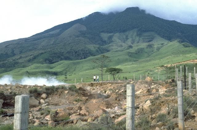
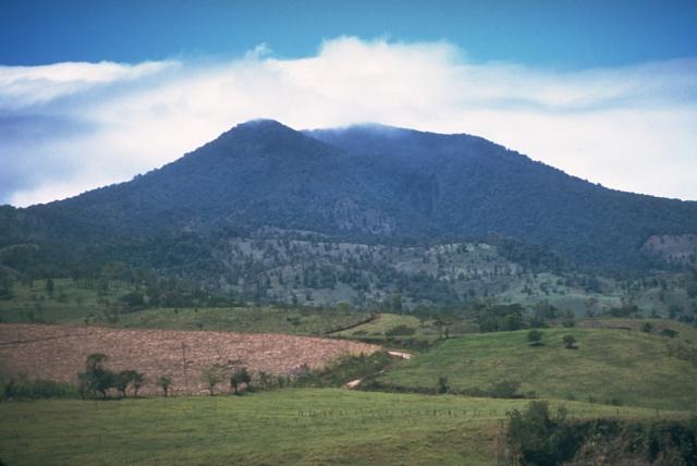
The 225 km2 dominantly andesitic Tenorio volcanic massif anchors the SE end of the Guanacaste Range and consists of a cluster of densely forested NNW-SSE-trending volcanic cones. Overlapping lava flows from the principal peak, Tenorio, cover the NW-to-SW flanks and descend the NE flank. The NW-most of three craters on the central cone is sparsely vegetated and appears to be the most recently active. Volcán Montezuma to the north has two craters, the northern of which was the source of a lava flow to the NE. Additional pyroclastic cones are found to the NE and SW of the central complex, and the Bijagua lava domes were constructed on the N flank. A major debris avalanche covered about 100 km2 below the S flank. A legend exists of an eruption in 1816 CE, but the volcano was densely forested at the time of an 1864 visit by Seebach and no documented eruptions are known. Fumarolic activity is present on the NE flank.
— Smithsonian Institution, Global Volcanism Program
0 Recorded Eruptions
No eruption records available for Tenorio.
Real-Time Data
Frequently Asked Questions About Tenorio
Is Tenorio an active volcano?+
Tenorio is classified as active based on credible evidence of past eruptions. Although its last known eruption was in prehistoric times, volcanologists consider it capable of erupting again.
How high is Tenorio?+
Tenorio has a summit elevation of 1,916 meters (6,286 feet) above sea level. At 1,916 meters, it is a moderately sized volcanic peak, roughly comparable to Mount Vesuvius (1,281m).
What type of volcano is Tenorio?+
Tenorio is classified as a Stratovolcano(es). Stratovolcano(es) volcanoes have distinct geological characteristics that set them apart from other volcanic types.
Where is Tenorio located?+
Tenorio is located in Costa Rica, in the Middle America-Caribbean Volcanic Regions. More specifically, it lies within the Central America Volcanic Arc. Its exact coordinates are 10.673° latitude, -85.015° longitude.
Is it safe to visit Tenorio?+
Tenorio can generally be visited, but as with any volcano, visitors should check local conditions and any advisory notices before traveling. Costa Rica may have specific regulations for accessing volcanic areas. Guided tours are often the safest and most informative way to experience a volcano.